


🟢authorized PARTNER
SKU:3MPRS-1
3DMakerPro Raven SLAM LiDAR Scanner 3MPRS
3DMakerPro Raven SLAM LiDAR Scanner 3MPRS
✅Includes Warranty
✅30-Day Returns
✅Unlimited Free Support
Couldn't load pickup availability
Talk to Our Experts 🟢
Talk to Our Experts 🟢
3DMakerpro Raven LiDAR Scanner
Portable SLAM LiDAR for Surveying, Mapping, and Digital Twin Creation
Engineered for speed and usability, Raven enables users to capture large environments in minutes, generate colorized point clouds, and integrate seamlessly into CAD, BIM, and 3D workflows.
Key Advantages
-
2 cm accuracy for professional-grade spatial data
-
Up to 100 m scan range for large-scale environments
-
360° × 40° field of view minimizes blind spots
-
SLAM-based scanning with minimal setup
-
Ultra-lightweight (1.1 kg) for true portability
-
4K RGB capture + Gaussian splatting support
-
Swappable battery system (2-hour runtime)
-
Compatible with external 360 cameras for advanced workflows
Variants Comparison Chart
| Model | Camera System | RTK | Best For |
|---|---|---|---|
| Raven (Standard) | 1 × 12 MP | No | Entry-level professional scanning |
| Raven Max | 2 × 12 MP | No | Enhanced RGB capture & detail |
| Raven Max RTK | 2 × 12 MP | Yes | Survey-grade georeferenced workflows |

Specs & Scanning Performance
| Specification | Details |
|---|---|
| Accuracy | 2 cm @ 10 m / 3 cm @ 20 m / 5 cm @ 40 m |
| Scan Range | 80 – 100 m |
| Scan Radius | 40 m (@10% reflectivity) / 50 m (@80%) |
| Field of View | 360° (H) × 40° (V) |
| Point Rate | 150,000 points/sec |
| Laser | 905 nm |
| Safety | Class 1 Eye Safe |
Imaging & Visual Capture
-
12 MP camera system (dual on Max versions)
-
4K true-color texture capture
-
Automatic exposure for indoor & outdoor environments
-
Supports Gaussian splatting workflows
-
Optional 360 camera integration (e.g., Insta360 X4/X5)
Core Technologies
SLAM-Based Precision Mapping
-
Combines LiDAR + IMU + GPS + visual data
-
Reduces drift and improves alignment accuracy
-
Enables fast, real-time spatial capture
Ultra-Wide Coverage
-
360° horizontal scanning eliminates blind zones
-
Vertical 40° FOV ensures reliable single-pass scanning
Continuous Field Operation
-
Quick-swap battery system
-
Each battery supports up to 120 minutes runtime
-
Ideal for extended field sessions without downtime
Why Choose the Raven LiDAR Scanner
-
Combines portability + professional accuracy
-
One of the most cost-effective LiDAR solutions in its class
-
Supports both engineering-grade workflows and creative applications
-
Ideal for teams transitioning from traditional surveying to digital capture workflows
Applications

-
Surveying & Topographic Mapping
-
Construction Site Documentation
-
BIM & Renovation Workflows
-
Real Estate Digital Twins
-
Infrastructure & Facility Management
-
Underground / Low-Light Mapping
-
Urban & Street-Level Scanning
Real Estate | Raven : From Scan to Immersive Tour in One Hour
Field Surveying with the Raven Spatial Scanner - Designed for Creators & Field Work
Software Ecosystem
RayStudio (Included – Free)
-
Point cloud processing & visualization
-
AI-powered denoising
-
Advanced point cloud optimization
-
Multi-format export (CAD, BIM, GIS compatible)
JIMUMETA Platform
-
Cloud-based hosting for scans
-
Share immersive 3D environments
-
Supports Gaussian splatting visualization
Expansion Ecosystem (Optional Add-Ons)
| Add-On | Function |
|---|---|
| Battery Grip | 120 min runtime, hot-swappable |
| 360 Camera Kit | Enhanced RGB + Gaussian splatting |
| Bicycle Kit | Mobile street scanning |
| Rooftop Mount | Vehicle-based scanning |
| Backpack Kit | Portable scanning workflows |
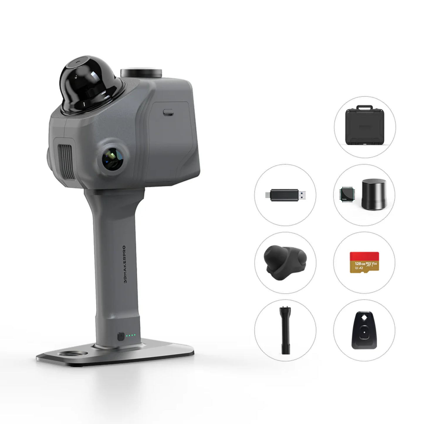
What’s Included in the Box
| Item | Included |
|---|---|
| Raven LiDAR Scanner | Yes |
| Battery Grip | Yes |
| Holder Base | Yes |
| Protective Case | Yes |
| 128GB TF Card | Yes |
| Charging & Data Cables | Yes |
Standard (1x camera)

Max (2x camera)

Max RTK (2x camera with RTK)

User Manual
The Raven LiDAR User Manual includes:
-
Device setup & calibration
-
SLAM scanning workflows
-
Data capture best practices
-
RGB and Gaussian splatting setup
-
Exporting to CAD/BIM formats
-
Maintenance & troubleshooting
📄 View/Download 3DMakerPro Raven User Manual
Brochure
The official brochure includes:
-
Product architecture overview
-
Variant comparison (Raven vs Max vs RTK)
-
Workflow diagrams
-
Real-world application use cases
📄 View/Download 3DMakerPro Raven Brochure
FAQs
What is the accuracy of the 3DMakerpro Raven LiDAR scanner?
The 3DMakerpro Raven LiDAR scanner delivers:
- 2 cm accuracy at 10 meters
- 3 cm accuracy at 20 meters
- 5 cm accuracy at 40 meters
This level of precision makes it suitable for surveying, construction documentation, and BIM workflows, especially for large-scale environments.
What is the maximum scanning range of the Raven LiDAR?
The Raven supports:
- Effective scan radius: up to 50 meters
- Maximum scan range: 80–100 meters
This allows users to scan large spaces like buildings, streets, stadiums, and outdoor environments in significantly less time compared to traditional methods.
Does the Raven LiDAR scanner support RTK for survey-grade accuracy?
- Standard Raven: ❌ No RTK
- Raven Max: ❌ No RTK
- Raven Max RTK: ✅ Includes RTK module
If your workflow requires georeferenced data and survey-grade positioning, the Raven Max RTK is the recommended configuration.
Can the Raven LiDAR scanner capture color (RGB) data?
Yes. The Raven includes:
- 12 MP camera (Standard)
- Dual 12 MP cameras (Max & RTK versions)
It captures 4K color textures, enabling:
- Colorized point clouds
- Photorealistic digital twins
- Gaussian splatting workflows
What software is included with the Raven LiDAR scanner?
The Raven includes free access to RayStudio, which provides:
- Point cloud processing
- AI-powered denoising
- Data optimization tools
- Export to CAD, BIM, and GIS formats
It also integrates with JIMUMETA, a cloud platform for sharing and hosting 3D environments.
How long does the battery last during scanning?
- Each battery provides up to 2 hours of continuous scanning
- The quick-swap battery system allows uninterrupted operation in the field
This is ideal for long survey sessions and large-scale scanning projects.
Is the Raven LiDAR suitable for outdoor and low-light environments?
Yes. The Raven is designed for:
- Outdoor scanning (construction sites, roads, terrain)
- Low-light environments (caves, basements, infrastructure)
Its LiDAR-based system does not rely on lighting conditions, ensuring consistent performance.
What industries commonly use the Raven LiDAR scanner?
The Raven is widely used in:
- Surveying & Geospatial Mapping
- Construction & Site Documentation
- Architecture & BIM
- Real Estate Digital Twins
- Infrastructure & Facility Management
- Engineering & Environmental Studies
Can I use the Raven LiDAR for mobile scanning (walking, vehicle, etc.)?
Yes. The Raven supports dynamic scanning workflows, including:
- Handheld scanning (walk-through mapping)
- Backpack-mounted scanning
- Vehicle-mounted scanning (rooftop mount)
- Bicycle or mobile rig setups
This flexibility makes it ideal for large-area capture and urban mapping.
Does the Raven LiDAR require targets or ground control points?
No, the Raven uses SLAM (Simultaneous Localization and Mapping):
- No targets required for basic scanning
- Minimal setup time
- Faster deployment in the field
However, for survey-grade accuracy, especially with the RTK version, control points may still be used for validation.
How does the Raven compare to traditional LiDAR scanners?
Compared to traditional LiDAR systems, Raven offers:
- Significantly lower cost
- Portable, handheld design (1.1 kg)
- Faster setup (no tripod required)
- Real-time scanning capability
It trades some ultra-high precision for speed, flexibility, and accessibility, making it ideal for modern digital workflows.
What file formats does the Raven LiDAR support?
Raven supports export to standard formats used in:
- CAD software (e.g., DWG, DXF workflows)
- BIM platforms
- Point cloud formats (LAS, PLY, OBJ, etc.)
This ensures compatibility with engineering, architecture, and 3D design pipelines.
Is the Raven LiDAR scanner beginner-friendly?
Yes. The Raven is designed for ease of use:
- Minimal setup required
- Real-time feedback via onboard display
- Intuitive software workflow
It is suitable for both professionals and teams transitioning into LiDAR scanning.
What makes the Raven LiDAR different from other SLAM scanners?
Key differentiators include:
- Affordable entry into LiDAR scanning
- Built-in RGB + Gaussian splatting capability
- Compact and lightweight design
- Integrated hardware + software ecosystem
This makes it one of the most accessible professional LiDAR scanners currently available.
Warranty
-
2-Year Manufacturer Warranty
-
Covers defects in materials and workmanship
-
Support provided through authorized partners and 3DMakerpro
📄 View 3DMakerPro 2-Year Standard Warranty


RETURN AND REFUND POLICY
Return and Refund Policy
Cancellations & Refunds: At Precision 3D Works we pride ourselves on having the best return policies in the industry. Cancel your order any time before it ships completely free of charge (exceptions apply such as custom orders, see below).
If you have questions, please send an email to support@precision3dworks.com or call us at +1(213) 698-8700
Cancellations (Before Order Ships)
If you need to cancel an order, please contact us as soon as possible so we can refund you in full before your order leaves the warehouse. Reach agents during business hours at +1(213) 698-8700, the chat in the bottom right, or email support@precision3dworks.com any time.
Cancellations of Custom Orders
Custom or made-to-order products cannot be canceled or refunded as these products are put into production specifically for your order.
These units are custom-made to your specification or created once you order. Once you place your order they start building your unit. Your warranty will guarantee you a fully functional and operational product. If it is not clear whether your order is custom or made to order, please message or call us.
All sales are final for Custom made and Made-to-order products.
Refunds and Returns.
If you need to exchange your product, you may do so. You, as the customer, are responsible for any shipping costs throughout any returns and exchange processes.
Due to drastically increasing LTL/freight shipping costs, any outright returns will incur a 25% cancellation fee + return shipping costs. If you are replacing the product with something else, we may be able to help you cover some of the costs depending on the product.
Returns Accepted Within 30 Days
Please note that we will only accept returns within 30 days from the date you receive the product. Beyond this period, we will not process returns.
Shipping Times
We promise to do our best to get your order to you as soon as possible. We provide estimated shipping times on the product pages. All orders are dispatched within 1-2 business days and delivered within 5-7 business days.
Order delays have proven to be unavoidable and outside of Precision 3D Works control. While this might be frustrating, we ask you to please be patient and understanding with us in these tough times. We thank you for your business and appreciate your patience.
Please Read the Following
When you are making a purchase from Precision 3D Works, you are acknowledging the following of the Exchange Agreement:
- I understand I am to inspect the package upon delivery, and notate and take pictures if there is any damage and provide it to Precision 3D Works within 24 hours of the product being delivered.
- I understand that I am responsible for the cost of return shipping and the cost of a new product shipping in the case of a refund or exchange.
- I understand that products need to be returned unopened and unused. An additional restocking fee may occur.
- I understand that if my order has left the warehouse, I am unable to receive a full refund.
- I understand that if I return my order once it has shipped, I will be responsible for paying any return shipping fees and restocking fees, which vary by product, but are usually around 25%.
Damages
Please inspect the packaging of your item(s) when they arrive, if you notice any damage, you should make note of it when signing for delivery. If your item(s) arrive damaged please send photos of the damage, box, and SKU, along with a brief description of the damage to support@precision3dworks.com and we will process an insurance claim on your behalf. Photos and videos must be sent for freight damage within 24 hours of arrival or the freight damage claim will not be valid. Any punctures or visible signs of exterior damage must be reported within 24 hours.
Warranty
Warranties vary depending upon the manufacturer - see individual product pages for details. Warranty damages occur over time and from use. If an item was damaged upon arrival, and not reported within 30 days, that is not a warranty claim.
Returns
The Precision 3D Works default is that customers will be responsible for all return shipping charges or re-consignment fees caused by customer error, unless otherwise stated on the product page.
All of our products have guaranteed warranty policies - meaning that you will 100% get a fully functional, operating product that you paid for without any extra expenses incurred on your end - please see individual product pages for details.
BOGO Promotions
In the event of a BOGO promotion, both items must be returned for a full refund. If one of the two items is returned, you will get a replacement of that item or store credit for the value of that item when purchased on its own. If your order has shipped, you (the buyer) will also be responsible for actual return shipping charges and depending on the manufacturer, potentially a restocking fee. Refunds will only be issued to the original credit card that you used when placing your order.
All customers agree that they have read, understand, and agree to the terms and conditions above.
Individual items will have varying refund and return policies depending on the manufacturer. Please see individual product pages for details or contact support@precision3dworks.com
Chargebacks
Our team of agents is here to assist you and resolve any issues. We have purposefully made our policies as fair as possible, and we believe they are the top in the industry. We are on your team. We are immediately responsive and will do all that we can to help you out and provide the best resolution.
Given this, any customer that files a fraudulent chargeback will be held criminally liable for theft. If you have not received a product, or have an issue with a product that you did receive, please contact us, and we will help you resolve your issue. Please do not file chargebacks for issues that we can resolve together. Thank you for shopping with us!
Contact support@precision3dworks.com for any questions.
BY USING THE SITE, YOU AGREE TO THESE TERMS OF USE; IF YOU DO NOT AGREE, DO NOT USE THE SITE.
Let customers speak for us
The order was delayed a little but arrived within the expected timeframe. The equipment works well and was in great condition. There are learning curves and challenges with the equipment but the staff has been very helpful in assisting our team with resolving any issues and setting us up for successful results. We appreciate the efforts of P3DW.
![[Used] FJ Dynamics Trion P2 SLAM LiDAR 3D Scanner FJDTRP2](https://cdn.shopify.com/s/files/1/0696/4215/8338/files/FJDTrionP21-0001_70x70.webp?v=1760800088)
Amazing seller would buy from them again
